Answer
IMO, Resolution A.982(24), Adopted on 1 December 2005
REVISED GUIDELINES FOR THE IDENTIFICATION AND DESIGNATION OF PARTICULARLY SENSITIVE SEA AREAS
APSSA is an area that needs special protection through action by IMO because of its significance for recognized ecological, socio-economic, or scientific attributes where such attributes may be vulnerable to damage by international shipping activities.
At the time of designation of a PSSA, an associated protective measure, which meets the requirements of the appropriate legal instrument establishing such measure, must have been approved or adopted by IMO to prevent, reduce, or eliminate the threat or identified vulnerability. Information on each of the PSS As that has been designated by IMO is available at www.imo.org.
* DIFFERENCE: PSSA vs Special Area
*PSSA can be protected by ships routing measures such as area to be avoided, an area within defined limits in which either navigation is particularly hazardous or it is exceptionally important to avoid casualty and which should be avoided by all ships or certain kind of ships * The criteria for the identification of particular sensitive areas and the criteria for determination of special areas are not mutually exclusive. * In many cases a particular sensitive area may be defined within a special area or vice a oversea. | |||
PSSA | Special Area | ||
1. | Protects areas from all potential threats from | Primarily focuses on pollution prevention under | |
international shipping, not just pollution, includes | special MARPOL annexes. E.g. Oil, Sewage, G arbage, | ||
traffic management, anchoring restrictions etc. | Air etc. | ||
2. | Designated based on ecological, social, cultural & | Designated based on specific oceanographic or | |
economic, or scientific & education criteria and | ecological conditions like poor water circulation or | ||
vulnerability from international shipping | high traffic areas | ||
3. | Governed by IMO through APM (Associated | Governed strictly under MARPOL with mandatory | |
Protective Measures) like ships, routing. | discharge restrictions | ||
4. | May include TSS (Traffic Separation Scheme), areas | Strict regulations on discharges e.g. oil, sewage based | |
to be avoided, or no anchoring zones. | on MARPOL annexes | ||
5. | Requires approval from MEPC | Designated under MARPOL Annexes with mandatory | |
rules for pollution. | |||
6. | PSSA areas – Great barrier reef region, The | Mediterranean Sea, Baltic Sea, Black Sea, Antarctic, | |
Wadden Sea, Canary Islands etc. | Gulf of Aden, Red Sea, Wider Caribbean region | ||
including Gulf of Mexico etc. | |||
PSSA CRITERIA
4.4 ECOLOGICAL, SOCIO-ECONOMIC, OR SCIENTIFIC CRITERIA FOR THE IDENTIFICATION OF A PARTICULARLY SENSITIVE SEA AREA
1. Ecological criteria
• Uniqueness or rarity – An area or ecosystem is unique if it is “the only one of its kind”. Habitats of rare,
threatened, or endangered species that occur only in one area
• Critical habitat – A sea area that may be essential for the survival, function, or recovery of fish stocks or
rare or endangered marine species, or for the support of large marine ecosystems.
• Dependency – An area where ecological processes are highly dependent on bIOtically structured systems
(e.g. coral reefs, kelp forests, mangrove forests, seagrass beds).
• Representativeness – An area that is an outstanding and illustrative example of specific biodiversity,
ecosystems, ecological or physiographic processes, or community or habitat types or other natural characteristics.
• Diversity – An area that may have an exceptional variety of species or genetic diversity or includes highly
varied ecosystems, habitats, and communities.
• Productivity – An area that has a particularly high rate of natural biological production. Such productivity is
the net result of biological and physical processes which result in an increase in biomass in areas such as oceanic fronts, upwelling areas and some gyres.
• Spawning or breeding grounds – An area that may be a Critical spawning or breeding ground or nursery area
for marine species which may spend the rest of their life-cycle elsewhere, or is recognized as migratory routes for fish, reptiles, birds, mammals, or invertebrates.
• Naturalness – An area that has experienced a relative lack of human-induced disturbance or degradation.
• Integrity – An area that is a biologically functional unit, an effective, self-sustaining ecological entity.
• Fragility – An area that is highly susceptible to degradation by natural events or by the activities of people.
• Bio-geographic importance – An area that either contains rare biogeographic qualities or is representative
of a biogeographic “type” or types, or contains unique or unusual biological, chemical, physical, or geological features.
2. Social, cultural and economic criteria
• Social or economic dependency – An area where the environmental quality and the use of living marine
resources are of particular social or economic importance, including fishing, recreation, tourism, and the livelihoods of people who depend on access to the area.
• Human dependency – An area that is of particular importance for the support of traditional subsistence or
food production activities or for the protection of the cultural resources of the local human populations.
• Cultural heritage – An area that is of particular importance because of the presence of significant historical
and archaeological sites.
3. Scientific and educational criteria
• Research – An area that has high scientific interest.
• Baseline for monitoring studies – An area that provides suitable baseline conditions with reg ard to biota or
environmental characteristics, because it has not had substantial perturbations or has been in such a state for a long period of time such that it is considered to be in a natural or near-natural condition.
• Education – An area that offers an exceptional opportunity to demonstrate particular natural phenomena.
5. VULNERABILITY TO IMPACTS FROM INTERNATIONAL SHIPPING
In addition to meeting at least one of the criteria listed in 4.4, the recognized attributes of the area should be at risk from international shipping activities.This involvesconsideration of the following factors:
Vessel traffic characteristics:-
• Operational factors – Types of maritime activities (e.g. small fishing boats, small pleasure craft, oil and g as
rigs) in the proposed area that by their presence may reduce the safety of navigation.
• Vessel types – Types of vessels passing through or adjacent to the area (e.g. high-speed vessels, large
tankers, or Bulk Carriers with small under-keel clearance).
• Traffic characteristics – Volume or concentration of traffic, vessel interaction, distance offshore or other
dangers to navigation, are such as to involve greater risk of collision or grounding.
• Harmful substances carried – type and quantity of substances on board, whether cargo, fuel or stores, that
would be harmful if released into the sea.
Natural factors:-
• Hydrographical – Water depth, bottom and coastline topography, lack of proximate safe anchorages and
other factors which call for increased navigational caution.
• Meteorological – Prevailing weather, wind strength and direction, atmospheric visibility and other factors
which increase the risk of collision and grounding and also the risk of damage to the sea area from discharges.
• Oceanographic – Tidal streams, ocean currents, ice, and other factors which increase the risk of collision
and grounding and also the risk of damage to the sea area from discharges.
*** At present there are total 17 PSSA. Last one:- Philippines(2017), Tub bataha Reef Natural Park, The Sulu Sea
PROCESS FOR DESIGNATION OF PSSA:-
3. PROCESS FOR THE DESIGNATION OF PARTICULARLY SENSITIVE SEA AREAS
• An IMO Member Government may submit a PSSA application to the IMO's Marine Environment
Protection Committee (MEPC), which meets approximately every eight months.
• It is important to note that a PSSA designation is not a stand-alone measure-it can only be achieved in
connection with one or more associated protective measures (APM) that are to be, or have been, approved by the IMO.
• AP MS are indispensable to a PSSA in that they "define the means by and the extent to which a PSSA is
protected against environmental threats posed by international shipping."
• Thus, any PSSA application must contain a proposal(s) for at least one APM that the IMO Member
Government intends to submit to the appropriate IMO body.
• If AP MS are already located within the area proposed for designation as a PSSA, then the PSSA
application must identify the threat of or actual damage being caused and show how the area is already being protected from such identified vulnerability by the existing APM.
• The MEPC will not make a final decision on PSSA designation until the accompanying APM(s) is
considered and adopted by the Maritime Safety Committee (MSC).
• Once MSC adopts the AP MS, MEPC will formally designate the area an official PSSA through a formal
resolution.
The following PSSAs have been designated:-
1.The Great Barrier Reef, Australia (designated a PSSA in 1990)
2.The Sabana-Camagüey Archipelago in | Cuba (1997) | |
3.Malpelo Island, Colombia (2002) | ||
10.The Galapagos Archipelago, Ecuador | (2005) | |
11.The Baltic Sea area, Denmark, Estoni ia, Finland, Germany, Latvia, Lithuania, Poland an nd Sweden (2005) 12.The Papahānaumokuākea Marine Na ational Monument, United States (2007) 13.The Strait of Bonifacio, France and Ita aly (2011) | ||
14.The Saba Bank, in the North-eastern | Caribbean area of the Kingdom of the Netherlan nds (2012) | |
15.Extension of Great Barrier Reef and T Torres Strait to encompass the south-west part o of the Coral Sea (2015) 16.The Jomard Entrance, Papua New Gu uinea (2016) 17.Tubbataha Reefs Natural Park, the Su ulu Sea, Philippines (2017) India status on PSSA:- | ||
Ind has made two proposal in the Anda | man and Lakshadweep. | |
But they are pending because they are n not matching the guidelines of IMO for designati on as PSSA. It will be taken up in the Next MEPC ses suasion. Q36- Djibouti Code. A – | ||
The Code of Conduct concerning the Re epression of Piracy and Armed Robbery against | Ships in the Western Indian | |
Ocean and the Gulf of Aden, also referr red to as the Djibouti Code of Conduct, was ado | pted on 29 January 2009 by | |
the representatives of: Djibouti, Ethiop pia, Kenya, Madagascar, Maldives, Seychelles, So omalia, the United Republic of Tanzania and Yemen. Comoros, Eg gypt, Eritrea, Jordan, Mauritius, Mozambique, O Oman, Saudi Arabia, South Africa, Sudan and the United Arab Emir rates have since signed bringing the total to 20 co ountries from the 21 eligible to sign. | ||
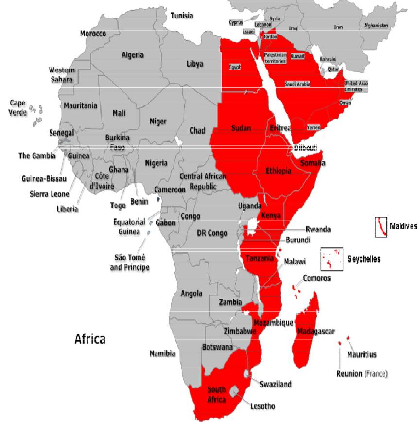
Under the Code, which became effective from the date it was signed, signatories declare their intention to co-operate to the fullest possible extent in the repression of piracy and armed robbery against ships. In particular the signatories to the Code have agreed to co-operate, in a manner consistent with international law, in:
(a)The investigation, arrest and prosecution of persons, who are reasonably suspected of having committed acts of piracy and armed robbery against ships, including those inciting or intentionally facilitating such acts
(b)The interdiction and seizure of suspect ships and property on board such ships;
(c)The rescue of ships, persons and property subject to piracy and armed robbery and the facilitation of proper care, treatment and repatriation of seafarers, fishermen, other shipboard personnel and passengers subject to such acts, particularly those who have been subjected to violence; and
(d)The conduct of shared operations – both among signatory States and with navies from countries outside the region – such as nominating law enforcement or other authorized officials to embark on patrol ships or aircraft of another signatory.
In addition, the Code provides a framework for communication, coordination and cooperation under its four thematic broad pillars:
A. Delivering national and regional training
B. Enhancing national legislation
C. Information sharing and Maritime Domain Awareness D. Building counter piracy capacity